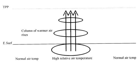
The TRS starts life as a tropical depression which forms due to thermal instability between the surface of the Earth and the tropopause (hot air rises). The low pressure is accounted for by the difference in temperature between the heated air and its surroundings. If there is a stable temperature lapse rate the depressions are rather small and insignificant, however if the temperature lapse rate should increase where it exceeds the limit of 'Atmospheric Stability' a deeper depression will occur. The problem will be amplified if the air is saturated, because the release of latent heat energy in the water vapour will contribute to the process of convection.
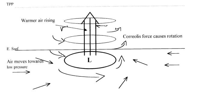
One of the conditions required for a TRS to develop is that it must be North or South of the equator. This is so correolis force has an effect. As the column of air rises an area of low pressure forms at the centre of the column and surrounding air moves in to replace it. As this air moves in the correolis force takes effect and our tropical depression is born. N. HEMISPHERE
What I have described above as a tropical depression is not the only way they form a tropical depression is any type of depression in the tropical latitudes and another formation is caused by an occasional 'shallow trough' which moves in an Easterly direction. If this becomes encircled by a couple of isobars it is also termed a tropical depression but is unlikely to develop further unless it encounters a large energy source. In order to place definition on what is what, in the tropical depression anoraks world, the following nomeculture is used.
1) Tropical Depression - Winds do not exceed force 7
2) Moderate Tropical Storm - Winds of force 8-9
3) Severe Tropical Storm - Winds of force 10-11
4) Hurricane - When winds reach force 12
It is an important point to know that a tropical
depression can intensify into a TRS within 12 hours! So
what happens to our tropical depression to make it a TRS
? There are many theories regarding what happens with an
intense depression and I like to think of it as an
inverted version of water running down a plug hole. The
latest thought is that due to the rising of the hot air a
high pressure zone is created in the Tropopause in a
similar fashion to the depressions along the lines of the
jet streams. Eventually as the speed of the rotating wind
increases the centrifugal force causes the high pressure
in the centre of the depression to descend towards the
Earths surface.  Of course this is just showing
the wind movement, as previously mentioned water vapour
is required to put in the energy, so there will be heavy
cloud around the formation as the warmer air rises and
the water vapour condenses.
Of course this is just showing
the wind movement, as previously mentioned water vapour
is required to put in the energy, so there will be heavy
cloud around the formation as the warmer air rises and
the water vapour condenses.
So below is our full TRS formation, in the centre is
the eye and there is little wind and conditions are
generally calm although there will be a very large swell.
There will be no cloud above the eye and good visibility.
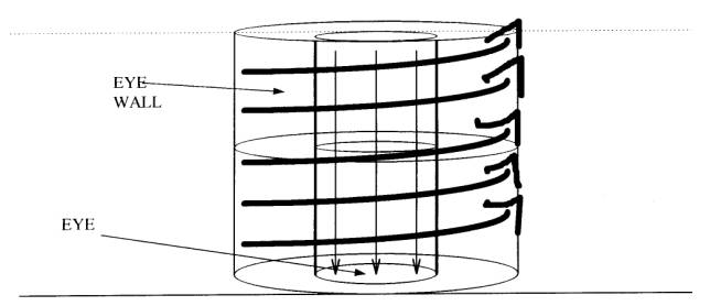 So we have the eye and the eye wall.
Outside that, the sphere of influence can reach as far as
250 NM with wind speeds of 45 to 125 knots. Below is a
schematic diagram of a TRS as seen from above.
So we have the eye and the eye wall.
Outside that, the sphere of influence can reach as far as
250 NM with wind speeds of 45 to 125 knots. Below is a
schematic diagram of a TRS as seen from above. 
So what conditions are needed to form a TRS?
1. Sufficiently large sea area
2. Removed from the equator
3. Region of vertical wind shear in the TPP
4. Pre existing depression .
Enough Energy Finally there is the associated weather to consider from a mariners point of view. Heavy rain, sometimes with thunder and lightning accompanies all TRS. Rain tends to occur in spiral bands in the outer region and becomes more intense and more widespread in the inner region reaching a maximum in the eye wall. With the light reduced by very dense cloud and the torrential rain the visibility is down to thick fog level. This however drops off as you approach the eye. Once through the eye the wind increases again followed by the rain etc. The wind eases off as you continue outward bound but this will take many hours and there is always a good chance of much damage to even the strongest Ships.